


Back to the Future
As urban planner Paul Shaker explains, Hamilton neighbourhoods have always been at the forefront of change and innovation. It’s time we learn from that legacy.
It’s not hyperbole to suggest that the soul of Hamilton can be found on the streets of its vibrant neighbourhoods. Some of these communities are over a century old, while others are new additions to the city’s urban fabric. Recently, with the strong support of residents, the city committed to maintaining a firm urban boundary, which means new population growth will need to be accommodated within existing neighbourhoods. While this is sure to usher in a period of significant growth that will shape and reshape neighbourhoods, it’s important to understand that we have been here before. The city has faced previous periods of growth and change and the urban planning response has been decidedly mixed. In some cases, urban sprawl has eaten up valuable farmland. However, there are a number of examples in Hamilton of progressive planning in the past that we should learn from and celebrate. In some cases, citizen advocacy led the way while others were examples of innovative community design.
Durand: Citizen-led planning
The historic neighbourhood of Durand sits south of the downtown core nestled below the Niagara Escarpment. It has a mix of different housing types ranging from apartment towers and mid-rise condos, to townhouses and stately single-family homes. The built heritage of the neighbourhood is a significant characteristic, which includes two Heritage Conservation Districts and some structures of provincial and national significance. However, the neighbourhood that is the Durand of today did not come easily. Through previous periods of growth, it took the determined effort of residents to shape the modern streets of Durand.
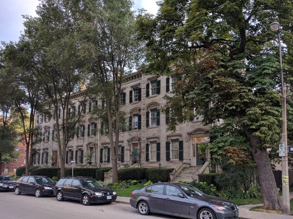
National Historic Site of Canada in 1975.
In the early 1970s, Durand was a neighbourhood in massive flux with numerous demolitions of homes and poorly designed high-rises taking their place. In the absence of a proper neighbourhood plan with community input, the rules favoured developers and things like urban design and heritage preservation were virtually non-existent.
It was in this scenario that the Durand Neighbourhood Association (DNA) was born and residents started to assert themselves in the planning process at City Hall. The first victory was a push for a halt to demolitions until a neighbourhood plan was developed. This was part of a larger project that looked to create plans for housing, traffic, schools, recreation, open space and commerce for each of the city’s more than 100 newly designated neighbourhoods. However, even with demolitions continuing all around them, the City told Durand residents to “wait their turn” for a plan.
Flipping the script, residents took matters into their own hands, hitting the streets to start a community conversation about the future of their neighbourhood. This was followed by petitions and a survey that forced the city to the planning table where a more collaborative approach to creating a neighbourhood plan took place. Issues such as an appropriate mix of high, medium, and low-density development, affordable housing, open space, safe streets and commercial spaces were discussed with the community. The resulting Durand neighbourhood plan went through various revisions before being approved in 1974. It wasn’t perfect, but it was a vast improvement from where things started.
The work of the DNA was nominated for a Citizen of the Year award where it was recognized that “the DNA has virtually overturned the accepted methods and procedures in terms of the role which citizens play in community affairs. The group has proven that people can redirect the planning process and the future lifestyle of a community and a city and has shown that our City must not necessarily come to the same horrendous situation which exists in other large cities in North America because of a lack of community participation, a lack of sound planning and a lack of passionate understanding of the needs of the community.”
The story of the engaged residents of Durand is relevant again today as growth and development are on the upswing once again and the need for neighbourhood plans with community participation are needed.
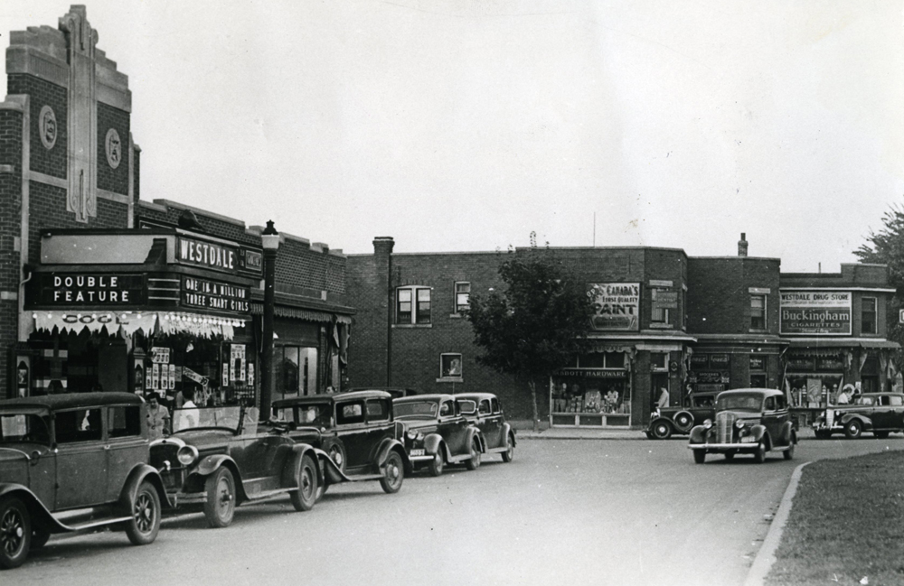
Westdale: A planned suburban community
When you think of “the suburbs,” often contemporary images of cul-de-sacs on the outskirts of town come to mind but their history extend much further. In fact, Hamilton is home to one of Canada’s first planned suburban communities. Westdale had its beginnings in 1911 and was conceived by architect Robert Pope as a self-contained neighbourhood for approximately 1,700 households with a concentric circle configuration for the street layout. It was inspired by the Garden City movement that was prevalent in German city models of the day.
Despite the expansion and changes over the years, the original design behind Westdale remains today. A quick look at Google Maps shows the distinct street ring pattern. The neighbourhood was planned to be centred around a commercial district on King Street, now the Westdale Village. Many shops and services are available for everyday needs, accessible on foot. There are higher-density buildings fronting on King Street, including mid-rise apartments. Moving into the residential streets, the density of housing, while lower than the inner city, demonstrates a good use of space. The neighbourhood is very walkable, with sidewalks connecting the neighbourhood from end to end. Schools, ranging from elementary to secondary, are located in the neighbourhood, most within walking distance of the original neighbourhood design. The ring design of the streets keeps traffic speeds slow, making the environment safer for pedestrians. The architecture of the houses provides some variation in style, while keeping general design features within a similar range (setbacks, heights, etc.). Also, parkland is provided nearby with Churchill Park and the trail system, ravines and wetlands of Cootes Paradise.
If you compare this neighbourhood design to that of many postwar suburbs, Westdale stands out as an urban innovator that we are only recently starting to recognize as a model to emulate. Typical suburban design is much lower density with many streets ending in cul-de-sacs, some without sidewalks. This creates a car-focused environment that doesn’t promote walking. Usually, the nearest commercial district is the shopping centre or big-box mall that is not within reasonable walking distance to homes. Schools are not within walking distance either and public spaces and the public realm are de-prioritized. All in all, the Westdale model is more sustainable, healthy and vibrant.
While social progress has broken down barriers that originally saw Westdale as an exclusive white Protestant neighbourhood, what has stood the test of time is the design of the neighbourhood itself. A century after it was conceived, the genius behind the design of Westdale is still evident today. Further, Westdale is a reminder of how Hamilton has been an urban innovator in the past.
The Mountain: Future-ready design
While people from elsewhere often look a bit confused when Hamiltonians refer to “the Mountain," all locals know exactly where it is. The area above the Niagara Escarpment is deeply embedded in the local civic identity, but that doesn’t mean it isn’t misunderstood. In fact, there is often the sense it is a homogenous suburban area. In reality, it is very diverse, with an interesting history and layered planning legacy. The Mountain is made up of a mixture of older established walkable neighbourhoods, postwar housing communities and newer suburban neighbourhoods. There are great shopping districts, along with traditional shopping centres. It has a major post-secondary institution, Mohawk College, and one of the city’s most notable historical landmarks, Auchmar.
The older part of Hamilton Mountain, the area generally north of Mohawk Road, also illustrates some innovative community planning that newer suburban development would be smart to emulate. City planners had the foresight to lay out a grid street system, similar to the pattern in the lower city, that would create self-contained neighbourhoods.
Within each large grid is a neighbourhood park and (originally) an elementary school, which was walkable by local neighbourhood kids. The larger arterial roads, carrying more traffic and commercial space, were confined to the edges of the neighbourhood.
This design has a number of benefits. First, traffic on interior streets can be kept slower, with faster speeds on the arterial reads. Second, neighbourhood amenities including shops, schools and parks are within walkable distance for neighbourhood residents. Third, major transit routes can service the arterial roads in an efficient way, ensuring that all residents in the neighbourhood are within walking distance of some form of transit. Fourth, the grid pattern provides multiple routes to get around, rather than the more modern subdivision design which has a limited number of neighbourhood entries, creating traffic jams.
This is in stark contrast to the typically suburban form prevalent today, of more curvilinear streets with cul-de-sacs, which is far more automobile-oriented, and not conducive to walking or transit.
Further, we can appreciate that this design was ahead of its time and essentially future-ready. As we now need to plan for more growth within the existing urban boundary, the grid pattern provides an excellent blueprint for intensification. All along the major commercial streets, there is an opportunity for larger growth and development. Streetscapes on major arteries can easily support an increase in height, accommodating more mixed-used commercial/residential development. In turn, this would increase residential density and jobs and support the expansion of rapid transit. In contrast, this leaves the interior of neighbourhoods relatively intact and able to accommodate more forms of gentle density, such as secondary suites, duplexes and townhouses.
Hamilton’s neighbourhoods have always been on the forefront of change.
Whether they were facing intensification or being created from scratch, the resulting streets, houses, parks and schools are the building blocks that make up the modern city. As we now enter another period of significant growth, neighbourhoods across the city will experience change, one way or another. In turn, how we react and shape that change will define the city of tomorrow.
On that front, we can take inspiration from the past as we build the next Hamilton.
Paul Shaker is a Hamilton-based urban planner and principal with Civicplan.